Brisbane, the capital of Queensland, is a vibrant city brimming with picturesque landscapes, lush parklands, and a lively urban center. I have explored numerous walking and cycling routes throughout Brisbane’s city center. I will detail three of my personal favorite routes and recommend four additional routes that are worth exploring. I will share my experiences, the pros and cons of each route, their exact locations, how to get there, available services, and booking platforms. Let’s embark on a journey to discover Brisbane’s best walking and cycling paths.
My Walking and Cycling Experiences in Brisbane
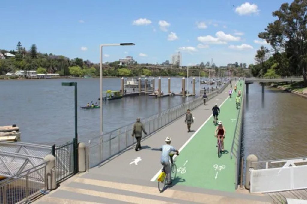
1. South Bank to Kangaroo Point Cliffs Walk
Location: South Bank Parklands, Brisbane
Distance: Approximately 5 kilometers (round trip)
Duration: 1.5 to 2 hours
Difficulty: Easy to moderate
Experience:
Starting at the iconic South Bank Parklands, this walk takes you along the southern bank of the Brisbane River, past the picturesque Streets Beach, and over the Goodwill Bridge to the Kangaroo Point Cliffs. The path is well-paved and offers stunning views of the Brisbane skyline, river, and parklands.
Walking along the South Bank, I was greeted by vibrant gardens, fountains, and public art installations. The area is bustling with activity, especially on weekends, with numerous cafes, restaurants, and markets. Crossing the Goodwill Bridge provided panoramic views of the city and the river below. The Kangaroo Point Cliffs are a highlight, offering a serene escape from the urban hustle and fantastic lookout points.
Pros:
- Scenic route with diverse attractions
- Accessible for all fitness levels
- Numerous cafes and amenities along the way
Cons:
- Can be crowded during peak times
- Limited shade on the Kangaroo Point Cliffs section
Tips:
- Start early in the morning or late afternoon to avoid the heat
- Wear comfortable walking shoes and bring water
- Take time to explore the South Bank Parklands and enjoy a coffee at one of the riverside cafes
Getting There: South Bank Parklands is easily accessible by public transport, including bus, train, and ferry services. There are also several parking options available nearby.
2. Brisbane River Loop Cycle
Location: Brisbane River, Brisbane
Distance: Approximately 35 kilometers
Duration: 2 to 3 hours
Difficulty: Moderate
Experience:
The Brisbane River Loop is a popular cycling route that circles the Brisbane River, taking you through several suburbs, including South Bank, West End, St Lucia, Toowong, and the Brisbane CBD. This loop is a favorite among local cyclists and offers a mix of urban and natural scenery.
I started my ride at the South Bank, heading west towards the University of Queensland in St Lucia. The path is well-maintained, with dedicated cycling lanes in most sections. Riding along the river, I enjoyed the lush greenery of the Botanic Gardens and the vibrant atmosphere of the West End markets. Crossing the Indooroopilly Bridge, I made my way back along the northern bank of the river, passing through Toowong and the CBD.
Pros:
- Varied scenery with urban and natural elements
- Well-maintained and signposted paths
- Suitable for intermediate cyclists
Cons:
- Some sections can be busy with pedestrians
- A few steep inclines and declines
Tips:
- Ensure your bike is in good condition before starting
- Carry plenty of water and snacks for the journey
- Use a bike map app to stay on track and find rest stops
Getting There: The loop can be accessed from various points, but starting at South Bank or the Brisbane CBD is convenient due to the availability of public transport and parking facilities.
3. Roma Street Parkland Walk
Location: Roma Street Parkland, Brisbane
Distance: Approximately 2 kilometers (round trip)
Duration: 1 hour
Difficulty: Easy
Experience:
Roma Street Parkland is a beautifully landscaped urban park located in the heart of Brisbane. The park features themed gardens, expansive lawns, and winding walking paths. It’s an ideal spot for a leisurely walk or a relaxing day out.
During my visit, I strolled through the different garden areas, each showcasing unique plant species and designs. The Spectacle Garden was particularly impressive, with vibrant flower displays and carefully curated plants. The walk around the park is easy and accessible, with plenty of benches and shaded areas to rest and take in the scenery.
Pros:
- Beautifully landscaped gardens and lawns
- Easy and accessible for all ages and fitness levels
- Plenty of seating and picnic spots
Cons:
- Limited length for those seeking a longer walk
- Can get busy during weekends and public holidays
Tips:
- Bring a picnic and enjoy lunch in the park
- Visit the park’s information center for a map and details about the gardens
- Wear comfortable shoes and sun protection
Getting There: Roma Street Parkland is easily accessible by train, bus, and car. The Roma Street train station is adjacent to the park, and there is ample parking available nearby.
Recommended Walking and Cycling Routes Around Brisbane
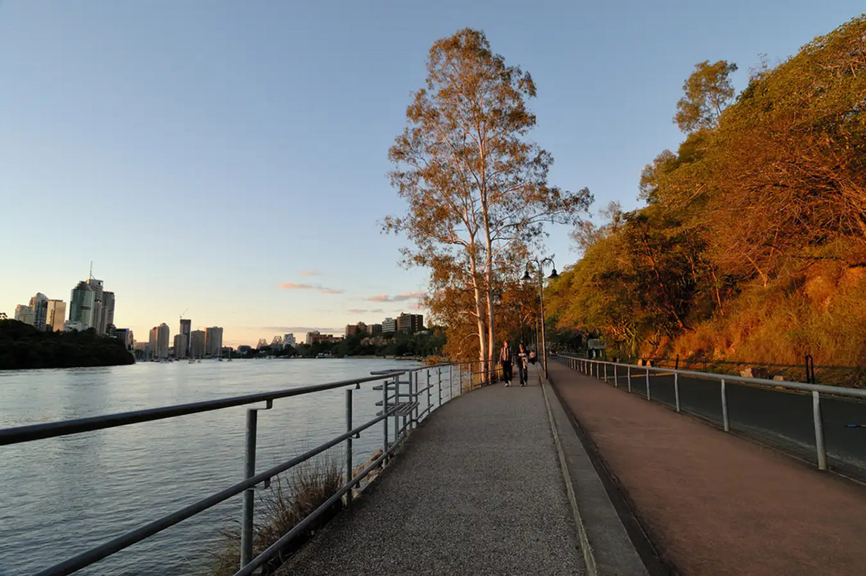
1. Riverwalk Pathway
Location: New Farm to Howard Smith Wharves, Brisbane
Distance: Approximately 4 kilometers (one way)
Duration: 1 to 1.5 hours
Difficulty: Easy
Experience:
The Riverwalk Pathway is a scenic pedestrian and cycling route that connects New Farm to Howard Smith Wharves, following the Brisbane River. This elevated walkway offers stunning river views and an easy, flat path perfect for a leisurely stroll or bike ride.
Starting at New Farm Park, the pathway winds along the river, passing the historic New Farm Powerhouse and continuing towards the vibrant Howard Smith Wharves precinct. The walkway is well-maintained and offers plenty of benches and viewpoints along the way.
Pros:
- Scenic river views
- Flat and accessible path
- Connects to popular destinations
Cons:
- Can be crowded during peak times
- Limited shade in some sections
Tips:
- Enjoy a meal or drink at Howard Smith Wharves
- Bring a hat and sunscreen for sun protection
- Combine with a visit to New Farm Park or the Powerhouse
Getting There: The Riverwalk Pathway is accessible from New Farm Park and Howard Smith Wharves. Both locations are well-served by public transport, and parking is available nearby.
2. Mt Coot-tha Summit Track
Location: Mt Coot-tha, Brisbane
Distance: Approximately 1.9 kilometers (one way)
Duration: 1 to 1.5 hours (one way)
Difficulty: Moderate
Experience:
The Mt Coot-tha Summit Track is a popular hiking trail that leads to the summit of Mt Coot-tha, offering panoramic views of Brisbane and the surrounding region. The track is well-marked and winds through lush forest, making it a pleasant and invigorating walk.
I started my hike at the JC Slaughter Falls picnic area, where the trailhead is located. The path climbs steadily, with some steep sections, but the effort is rewarded with breathtaking views from the summit lookout. The summit area has a cafe, where I enjoyed a refreshing drink while taking in the views.
Pros:
- Stunning panoramic views from the summit
- Well-maintained and marked trail
- Cafe and facilities at the summit
Cons:
- Can be challenging for those with lower fitness levels
- Busy on weekends and public holidays
Tips:
- Wear sturdy hiking shoes and bring plenty of water
- Start early in the day to avoid the heat
- Take breaks at the picnic areas along the trail
Getting There: The JC Slaughter Falls picnic area is accessible by car, with ample parking available. Public transport options include buses that stop near the base of Mt Coot-tha.
3. City Botanic Gardens Walk
Location: Alice Street, Brisbane
Distance: Approximately 2 kilometers (round trip)
Duration: 1 hour
Difficulty: Easy
Experience:
The City Botanic Gardens, located at the edge of the Brisbane CBD, offer a serene escape with beautifully landscaped gardens and walking paths. The gardens are a favorite spot for both locals and visitors looking to relax and enjoy nature.
I took a leisurely walk through the gardens, starting at the Alice Street entrance. The paths wind through various themed garden areas, including a rainforest grove, bamboo grove, and the iconic Weeping Fig Avenue. The gardens are well-maintained, with plenty of benches and shaded areas.
Pros:
- Beautifully landscaped gardens
- Easy and accessible paths
- Tranquil and relaxing environment
Cons:
- Limited length for those seeking a longer walk
- Can be busy during peak times
Tips:
- Visit the gardens’ information center for a map and details about the plants
- Bring a picnic and enjoy lunch on the lawns
- Wear comfortable shoes and sun protection
Getting There: The City Botanic Gardens are easily accessible by public transport, with several bus stops nearby. Parking is available in the surrounding streets and in nearby parking lots.
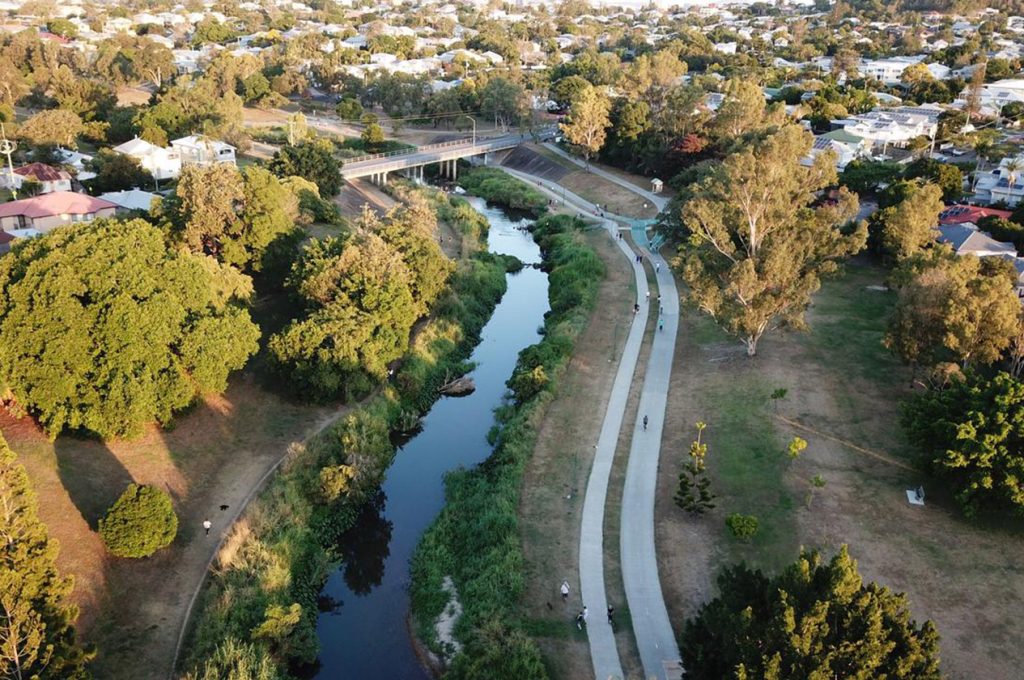
4. Kedron Brook Bikeway
Location: Kedron Brook, Brisbane
Distance: Approximately 16 kilometers (one way)
Duration: 1.5 to 2 hours
Difficulty: Easy to moderate
Experience:
The Kedron Brook Bikeway is a long, scenic cycling route that follows Kedron Brook through Brisbane’s northern suburbs. The bikeway is well-paved and offers a mix of urban and natural scenery, making it a popular choice for cyclists of all levels.
Starting at Toombul Shopping Centre, I cycled along the bikeway, enjoying the peaceful surroundings and the sound of the flowing brook. The path passes through several parks and green spaces, offering plenty of opportunities to stop and rest. The bikeway ends at the Brookside Shopping Centre in Mitchelton.
Pros:
- Scenic and peaceful route
- Well-paved and maintained path
- Suitable for all levels of cyclists
Cons:
- Limited amenities along the route
- Some sections can be busy with pedestrians
Tips:
- Carry water and snacks for the journey
- Use a bike map app to stay on track
- Take breaks at the parks along the way
Getting There: The Kedron Brook Bikeway can be accessed from various points along its route, with convenient starting points at Toombul Shopping Centre and Brookside Shopping Centre. Both locations are accessible by public transport and have parking facilities.
Brisbane offers a plethora of walking and cycling routes that cater to all fitness levels and preferences. Whether you’re looking for a leisurely stroll through landscaped gardens, a challenging hike with stunning views, or a scenic bike ride along the river, Brisbane has something to offer. My personal adventures have been filled with breathtaking scenery, vibrant urban life, and a deep appreciation for the natural beauty that this city has to offer.
Plan your routes ahead, take advantage of the numerous amenities and services available, and most importantly, enjoy the journey. Brisbane’s walking and cycling paths are not just routes; they are experiences that connect you with the city’s heart and soul. Happy exploring!